Monday, October 11, 2010

Coming soon:

a final data sheet on my hike. And then I have to figure out what I want to do with this blog.


As you can see from the sparsity of posts I've not been around here much. Grad school is occupying!

-ink

Wednesday, September 1, 2010

I'll see you in September

New posts coming soon, guys, I promise!

I've got acres of words, stories and images to share from the trail, circa northern Virginia to Pennsylvania and then another round of New England hiking. At the same time I've recently [very recently] moved to South Philly to begin grad school. This has meant I've been busy with moving and setting up a life, however temporary, here, in this teeming urban environment. I swear there's but one tree, a sapling, on my entire block. Quite different from the Trail.

My absences will be shorter.

-Ink, the once and future

Tuesday, July 20, 2010

Upper Goose Pond

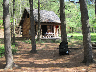
[The cabin at Upper Goose Pond.]

I got off the bus in Lee, Ma. and stepped straight into a high-powered storm. I sprinted for cover but not before hitting a parking lot flash flood that soaked me to my calves. A taxi brought me to the trailhead and a 1.6 mile southbound hike brought me here, where a nice family is serving as caretaker.

Zero day today, pancakes for breakfast and Dalton tomorrow. Then a 20-mile-a-day dash to Manchester, Vt. by Sunday.

Monday, July 19, 2010

Warm welcome back to the Trail

[Sudden thunderstorm hits Lee, Massachusetts, July 19.]

Now boarding: the Vermonter

After like a month off in Pennsylvania, during which I got my grad school future that much more sorted out, I'm traveling trailwards again.

Here commences MA->NH '10!

I'm hoping for new memories, new friends and to catch up with my friends from this spring. Surely I'll be taking it easy because of the heat-I'm built for cool temps-and I'd like to savor lovely Vermont and rugged New Hampshire.

Saturday, July 3, 2010

Harper's, 6/6/10

Thru-hiker! Technically, at least. I did the 2,175 miles in under a year. Which makes it so.


[The ATC hq, the place I started a year ago.]


[Somebody toss me the mic!]

I briefly entertained the idea of re-hiking WV->ME and clock 3,000 miles, completing a traditional thru-hike. But, it got too hot, I have too much business to attend to to be ready for grad school [less than two months away!] and I require novelty to drive me. So I'm off the trail. I am coming back to hike a section I'm keen to hike, and shortly. That would be Dalton, Mass. to at least Rutland, but perhaps to Gorham or Andover.

I'll keep you in the loop. And I'm going to add more posts about upper VA->upper PA.

Happy 4th! This time last year I was celebrating at The Mayor's House in Unionville, NJ. Remember that?

Thursday, June 24, 2010

Palmerton once again

I've hiked beyond Harper's Ferry, beyond the half-gallon challenge and Duncannon to Palmerton, PA, which longtime readers of this blog will know became a special place for me roughly this same time one year ago.

I'm not sure how much hiking I've got in me today as I'm feeling much under the weather, despite a zero at my girlfriend's family's house yesterday and several days off this week.

I'm still alive, still itching to keep you up to speed with my journey and still thinking of keeping hiking north. At the same time I've got a lot else going on, not least of which is preparing for grad school in the fall, at Temple University.

Nowadays I walk the Trail content knowing that I'm a thru hiker, with the whole 2,175 miles of the AT done in under a calendar year.

To be continued...

Sunday, June 6, 2010

June 6: V GA->WV Day

[Bears Den Hostel, northern Virginia. An amazing place built in the 1930s. Of all the hostels on the Trail, only this one reminds me of the kind of hostels that are travelers' oases in Europe.]

Less than three months after starting in Georgia, I am within a matter of hours of hiking today from reaching Harper's Ferry, W.Va., at 19 miles from where I'm sitting right now.

Time to get another picture of me for the books at the ATC!

And I'm not stopping. I've decided to continue at least as far as Duncannon, Pa. There will be a viewing party there for the USA-England World Cup match in six days.

Sunday, May 30, 2010

Update for Sunday, May 30: Waynesboro

So I'm in Waynesboro, Va. staying at Grace Lutheran Church.

The church has us in the basement on cots. They have two computers and a big screen tv for us in the lounge, hot showers and other amenities.

I hear there are like three snorers in the common room tonight. So I'm either going to couch it in here or use the earplugs that Cheeseburger gave me.

I got in today at noon, headed straight for Ming Garden and then straight to Tailgate, a bar and grill, to watch USA take on Turkey in soccer. I bought a used Jack London book - "John Barleycorn" - and resupplied at Kroger. It's a great town; I wish I had time to zero here.

But I must hike on. I'm at mile 853 from Springer. Which means I'm roughly 150 miles from Harper's Ferry. Which is so, so hard to believe, that I've hiked from there to Katahdin and then from Georgia to there, and it's all coming to an end so soon - in the next week and a half. Ten days!!! Tomorrow, I begin the 100-mile Shenandoah National Park portion of the AT, renowned for its forgiving terrain and wayside lunch counters. After the Shenandoahs I'm practically there.

I'm having a lot of mixed feelings being this close to the end of my 2,179 miles of hiking the Appalachian Trail. As I wrote in the register of the Priest Mountain Shelter, this trip took on more importance than I ever thought it would when I was planning it. Now I can hardly imagine my life without the Trail.

It's late. I'm off to bed, dreaming of AYCE blueberry pancakes.

Crossing the James River, Bluff Mountain

May 24, morning, Thunder Hill Shelter. It was raining hard outside the shelter, and had been during the night, too. Nobody wanted to go out in it. It was me, an older guy from Kentucky named Kentucky, an older guy from Germany named Eddy and a girl named Cowgirl and her dog. I felt sticky all over from sweat that hadn't dried off of me.

Of course, I hiked, as one does out here on the Trail. I've never yet zeroed at a shelter [though I neroed way back in lower NC].

I don't remember much of the day other than that I had NPR on the radio for a bit and told Cowgirl the good news, but she didn't know what NPR was. I definitely ate a lot of snack food for lunch at a crossing with a forest service road.

The James River, at 775 miles from Springer, has to be a highlight. Like the Susquehanna, the Hudson, the Kennebec, the Housatonic, the Nantahala and the Tye, one remembers the James, because rivers always stand out.


[The AT crosses the James River on a footbridge. May 24.]

You're supposed to jump off the bridge at a certain point and swim. But I was alone and why bother? After the bridge I hit Johns Hollow Shelter at about 5 p.m. Tents were up, a fire was going and people were hanging out for the night. I cooked mac and cheese. All the while I was debating, do I hike, do I stay? In the end, I hiked. It's hard for me to waste daylight when I'm full of energy.

So up the hill I went. Across Little and Big Rocky Row and Saddle Gap I was treated to beautiful evening ridge walking, with amazing vistas. A grouse fluttered across the trail and I wondered if I'd see more wildlife.


[Three ridges tapering from Apple Orchard Mountain into the James River, May 24.]

At 9 p.m. I hiked to the summit of Bluff Mountain, about which my companion book has this to say:

"Site of a monument to four-year-old Ottie Cline Powell. In the fall of 1890, Ottie went into the woods to gather firewood for his schoolhouse and never returned. His body was found five months later on top of this mountain..."

I shone my headlamp on the memorial marking the exact spot where they found his body. People had left stones stacked on the monument, which is pretty common for monuments along the Trail. I scanned around for a stone to place there but couldn't easily find one and moved out of the woods to the summit. The remnants of a firetower remained [Earl Shaffer camped there in 1948, I would later read]. I left my girlfriend a message as a fog bank rolled up and obscured the faraway lights of some town in the valley.

The moon was full. "OK, I've had enough of this," I thought, and hurried off to hike down the hill. I got a chill down my neck walking the switchbacks, broke into an all-out run. Sweat pouring off me, I realized how terrible it might be if I rounded a dark corner and literally ran into an unsuspecting bear, so I started chanting like a crazed Marine - "Hoo-Hah!"

I ended my night at Punchbowl Shelter, where I set up my tent. At about 11 p.m. I was startled by a limb crashing to the ground in the woods behind me [I was the furthest tent away from the shelter]. Not taking any chances on it being a coincidence, I went out in my boxer shorts to hang a bear bag. It was the end of a 25-mile day.

Hiking as a couple!

From Lamberts Meadow I hiked 10 miles north, went back to the Howard Johnson and promptly checked into room 301. I did some eating at Pizza Hut, did some blogging in the hotel lobby and waited for my girlfriend, Ashley, who was driving down from Pennsylvania to do a section with me.

We'd been planning this for months. In fact, we took our first trip to REI together in the winter to get her a pack to begin the gearing up process. And she'd been following up ever since.

She got there that night. The next day we resupplied at Kroger and went back to the room to get the "hurricane" of food and equipment funneled into our packs. We were off to do some hiking.

Hiking with a partner is something I find I increasingly enjoy. We sang duets, and Ashley, a music teacher and former pop singer in her high school days, taught me about harmonies. She had me hum a 'C' note, and then she added her own voice in harmony. "Hear how it's pretty?" she asked, leading the way up the trail.


[Ashley dismounting a stile, just north of Daleville, May 20.]


[Cow! May 20.]

We played "Six Degrees," which I rocked at. We watched a train go by. We finished our first day as a trail couple at Wilson Creek Shelter, an 11-mile day, and set up the tent. Having Ashley in the tent made me sleep all the more soundly.

In the morning, we took it slow. I gots to have my coffee.

This part of the trail wound back and forth across the Blue Ridge Parkway in places where we could peer over the edge of the ridge on both sides and see into West Virginia, where the Allegheny range paralleled us, or onto the Peaks of Otter, a resort-encrusted mountain jutting to the east.


[I discovered a curious artifact on the trail very close to the Blue Ridge Parkway.]

After a long day [14 miles] we tented again at Cove Mountain Shelter. Ashley was out of it until we had dinner.

On our third day together we took it real easy. We hiked to Jennings Creek, walked a bit up the road and hitched a ride in the back of a pickup truck to Middle Creek Campground and went to the country store for some hot food and cold, carbonated drinks. We played air hockey in the store's "arcade" and then shot hoops at the basketball court. By court, I mean a 20 ft by 20 ft paved square with a hoop. As a bonus, the register was one of the rare ones to contain entries from the class of 2009. It was nice to read that people I've hiked with had a good time there a year earlier.

Afterward we hiked the mile or so back to the trail and started climbing. The sky opened up and dumped a torrent of fresh rain on us. It seemed like minutes later the storm was done and we were nearing Bryant Ridge Shelter, our intended destination.

"Getting in at 4:30, just like the old men do it," I said. The deluxe two-story shelter loomed above the creek and trail. And as a matter of fact four old men already occupied it.

There was so much room that I pitched my tent, without the rain fly, on the top level. Two young hikers, T-Funk and Rock and Roll, showed up later and set up across the room on the same floor. As we bedded down, a long, drawn-out fart ripped through the country for old men down below. It was material for comedy among us younger ones in the morning. Ashley suggested, in the register, a fireman's pole or a slide into a ball pit for getting down from the top level of the shelter.

The next day Ashley got to climb all morning as we made our way up to Floyd Mountain. It was 1,000 feet up in the damp hot air. And we had to hurry, because we had to meet a shuttle back to Daleville at noon where the Blue Ridge Parkway connects with a short side trail from Cornelius Creek Shelter. I ran the last half of a mile or so and bade the shuttle man wait, and soon we were headed south on the parkway. We spotted a wild turkey - the only one I've seen so far - on the side of the road.

We took strong advantage of Ashley's car and drove south from Daleville 20 minutes to Catawba, home of the legendary Homeplace restaurant. The restaurant is open only Thursday through Sunday - I'd missed it because of Trail Days. We put our names on the list and waited while a man with a Virginia drawl called out parties on the outdoor loudspeakers. Lots of people wore church clothes, it being Sunday. The restaurant's simplicity is its strong suit. It's AYCE, and the menu consists of fried chicken, country ham, roast beef and a smattering of fixins, including biscuits and some insanely good apple butter.

I felt rejuvenated by food.


[Me and Ashley at the Homeplace, Catawba, Va. The shot was at the end of a series on self timer, hence the pose. May 23.]

After resupplying at the Daleville Kroger again, Ashley drove me to the side trail to Cornelius Creek Shelter, where we parted.

I thought about stopping for the night, but changed my mind and summited Apple Orchard Mountain [elev. 4,225 ft] on my way to Thunder Hill Shelter, arriving just after 8 p.m.

Saturday, May 29, 2010

After Trail Days: Daleville zero, trail maj and McAffee Knob

I had a Trail Days hangover.

Instead of resuming my hike immediately after Trail Days at mile 693 from Springer, I got a ride from Zipper [AT '09] 20+ further up to Daleville, where the AT encounters a bustling Interstate junction. I split a room at the Howard Johnson, next to the trail, with a hiker named Shorts. Sipping beer and watching tv in the A/C after two days of sipping beer in Tent City and Damascus relaxed me miraculously. And then I zeroed the next day because I really needed to catch up on this blog. It was raining buckets all day anyway.

But I was in the process of laying my clothes out to dry on the sidewalk outside my room when I glanced into the adjacent room and saw some dude. "Wait a sec," I thought, recognizing the Fila hat that Tintin had bought in Abingdon before a group of us went to the movies. It was Tintin, Fredo and Tornado, slowly getting ready to hike out. They'd abstained from Trail Days in vain, it appeared.

On the day I was due to hike I was buying coffee and a Danish at the coffee shop next to the outfitter in Daleville, in the plaza down the road from the HoJo.

"Excuse me," a young man who looked likely to be a Virginia Tech student [Blacksburg is very close] said. "Can I pay for you, sir?"

I was momentarily speechless. The barista meanwhile swiped my card. "Can you cancel that?" he said. We shook hands, exchanged names. He asked how the Trail was. I left feeling blessed.

I got a ride back down to where I was on the trail from Creepy, who was returning a rental car to Pearisburg.

It was May 18, a rainy day on which to hit McAffee Knob, one of the most iconic landmarks on the AT. Hikers put almost as much effort into McAffee Knob photos as Katahdin ones.

Being on my own again, I set my camera to timer and hurried over there. Here's what I came up with:


[Me at McAffee Knob, May 18.]

I hiked on to Tinker Cliffs, another renowned overlook, and experienced another fogbank fail. I sang loud as I finished my 16 mile day into Lamberts Meadow Shelter, where I stayed with three people - a woman from Israel named "Kutsa" and two older section hikers - I didn't know. Someone had left cans of soda in the creek for trail magic.

Wednesday, May 26, 2010

To Harper's Ferry: 198 miles

Argh. Can't upload photos. I'm at Dutch Haus B&B in Montebello, Va. American Idol is on so I'm on the computer.

I can't believe that my GA->WV '10 is now about two weeks from being over. I have fewer than 200 miles of hiking, or less than 10 percent of the Trail, between me and my finish point at Harper's Ferry.

Two weeks! 2,179 miles will be behind me!

I'm already thinking about the sections I'll be coming back for.

Trail Days!

Remember how skeptical I was about hitching to Trail Days from central Virginia?

I'm a worrywort.

I hung around the gas station/deli at trail mile 693.4, just six miles short of Catawba, and had a nice breakfast of ham biscuit. I asked the ladies at the counter for a piece of cardboard and a marker so I could make a hitchin' sign. "Trail Days bound!!!" it said enthusiastically. Then I waited a bit and Long Shanks, Inferno, Cookie and Tic Toc and Lola and Sunrise showed up. Long Shanks made himself a sign and we moved to the road, a moderately busy highway [Va. Rte. 311] and stuck out our thumbs while the rest of the gang watched with interest from a picnic table behind the gas station.

Twenty minutes later we were in the back of a pickup truck headed to the intersection of 311 and Interstate 81 - that crucial road that would take us all the way down to Damascus, which was all the way down at about mile 500 [edit: mile 460] from Springer.

Once at the intersection, we decided we'd probably have the best luck if we set up with our signs and packs right where the on-ramp enters the interstate. I jammed my poles into the dirt and was lifting my sign when a car pulled over and picked us up. It was a young couple, hikers, heading the whole way from western Maryland of all places. Clutch ride! I couldn't believe our luck. To boot they had a great music selection to jam to.

As soon as we got to town we [Long Shanks and I] headed straight into one of my favorite town spots in the South: Quincey's Pizza. Huge beers, hot food, good times.

Tent City: A bulldozed wasteland at the end of Shady Lane, on the edge of town [the town is making some ball fields], ringed by a woods. At first glance, nothing was visible but a few people picking their way through the dirt and uprooted roots to get to the road into the town. At a closer look, dozens, maybe hundreds, of tents occupied the flat spaces between the trees and people were hanging out. Near the gathering of the Class of '09 was a group playing Dizzy Bat, a drinking game involving placing one's forehead on a bat handle and spinning around. There was "Alcatraz," a camp in a little island in the creek running through the woods; "Camp Riff Raff," a place for heathens, "Billville," etc. etc.

Some people from last year made it; many didn't. It was strange coming from where I came from, stealthing in the woods, two months in the woods, and seeing the people I'd met and known last summer - in the woods - who'd left their trail names behind and now wore them awkwardly after all that time down from Katahdin.

The Class of '09 held a reunion at 9 p.m. at Dot's Inn, a rustic, homely bar specializing in piss beer. It was good times. The buzz never left. Almost everyone has remained connected, even if only through Facebook. There was catching up to do and people to meet again or for the first time, in the case of people I'd met, say, for one day in Monson, or for people who'd been around but never at the same place as me. It was clear to me that people overall missed the Trail and looked back on it with fondness.

On Saturday I did town stuff until the parade.

I had no preconceptions about the parade. I figured it would be just a stupid parade. But no. Before it started, the hikers congregated near Sun Dog Outfitters and the coffeeshop. Nothing was happening for the longest time. Some people showed up in costume [Col. Mustard was Green Man]. Then we came under heavy water-balloon fire. Some young townfolk were absolutely winging the water balloons at us from the parking lot. It was pretty hilarious when they hit their targets.

And that's how it was for the next 30 minutes, or however long it took to walk the entire main street through town. Hundreds of hikers, armed with water balloons and water guns, walking through a gauntlet of even more heavily armed townfolk. Neither side showed mercy: Dads in their khakis and sunglasses were just as likely to get blasted by a skirt-wearing hiker as we were by little kids throwing their hardest from point-blank range. Hikers from the current class spotted on the street but NOT marching got it the worst. That's what happened to Greendog and Pixie: an absolute pelting.

I did not expect to have that much fun, and it was therefore all the more fun. I just wish I'd had more - many more - water balloons.

The talent show afterward was a bit of wash. Some terrible comedy, bad rapping and a bunch of mediocre bluegrass. I did like bits of the song "Hiker Funk" performed by Many Names.

Saturday night consisted of beer in Tent City, a fire in the woods and sitting inside a big pavilion tent chanting names at full volume, in order to compete with the Dizzy Bat people and their loud counting-down. "Zen! Zen! Zen!," "Fat Kid! Fat Kid! Fat Kid!" It drew the attention of Damascus's finest, who entered the tent, flashlights out, and kind-of surveyed the scene before moving on. Not sure what they were trying to accomplish, as it was clear that the entire acre was one big open container. But my night ended relatively early, myself having been sleep-deprived, sun-baked and buzzed all freaking day.

Next morning, the '09ers did breakfast at Dairy King. There were hugs goodbye, and then I put my pack in Zipper's car for the long ride back up to central Virginia. Trail Days 2010 had come to an end.

Wednesday, May 19, 2010

The wet days before Trail Days


[Me on an overlook somewhere last week]

Really, when I look back on last week, the 60-mile stretch of trail from Rice Field Shelter to just before Catawba was a soggy blur of hiking.

I hit Keffer Oak, a famous 300-year-old tree:


[Keffer Oak, in a valley between Virginia fields, May 12]

I hit Dragon's Tooth, a famous rock outcropping at 691 miles from Springer:

[Dragon's Tooth, fogbank whitewall, May 13]

I did get to meet some cool new people, Inferno, Long Shanks, Shorts, Cookie and TicToc. But only Long Shanks and I planned to go to Trail Days...

Entering Central Virginia

I stayed at Woods Hole two nights, having hiked on May 9 the 10 miles between the hostel and the town of Pearisburg and getting a ride from Neville in the afternoon.

I was officially in Central Virginia, roughly 625 miles from Springer and less than 400 miles from Harper's Ferry, my endpoint. Getting close to the end!

It took me forever to exit the town. The trail would cross a road, enter a patch of woods and then reemerge onto the same road a short distance away. Repeat a few times, then hike up to a ridge and you're on your way.

Aaaannnd I saw two bears. !

The terrain was perfect bear country: Ridge top, with sparse trees allowing for wide open viewing, comfortaby tall grass. I spotted a medium-sized bear in the near distance and made noise instinctively. As soon as I realized I was there it jaunted off to the side. What I should have done was crept closer for a picture, if I'd known how skittish this one would be.

Not 10 minutes later I saw a younger bear chilling in the grass. This time I did stay quiet, but to no avail: It stuck its head up, spotted me, and repeated the move the first bear had done.

But it was a huge success for me. In one day I'd doubled my bear count from two, in New Jersey, to four.

At Rice Field Shelter, the first out of Pearisburg, I found a nice, deep shelter with a fire ring, all to myself. The shelter faced a meadow beyond a fence where one could spy incoming hikers.

Another new couple, West Virginia rafting guides named Lola and Sunrise, showed up, as did Moose and Tetherball and Freeman. It was one of the rare nights everybody in the shelter was up until about 11 p.m. or so, Tetherball checking his feet, Moose on the phone, Freeman stirring food in his pot, bundled up; Sunrise and Lola in the corner writing in their journals.

The next morning everyone except Moose and Tetherball stayed in the shelter. The weather turned really bad: Wind blowing the leaves sideways, rain hitting the tin roof. The fog obscured the meadow and sometimes even the fence and stile in front of the shelter.

I sat on my mattress and made coffee and oatmeal, very, very slowly because Pearisburg didn't sell fuel canisters and my backup was a Sterno can. I read an entire issue of SPIN magazine and fell back asleep.

When I woke up the storm was breaking, leaving only the wind. A ton of new people were showing up hoping to stay in the shelter, so the four of us from the previous night made an afternoon dash north. It was after dark when I got to Bailey Gap Shelter, where I found Lola and Sunrise and Willie Walker already cozy in their bags.

My Sterno took like 40 minutes to get the water and my noodles even warm. I ate it even though it had nevery boiled. The shells were sticky and gummy, mixed with salmon chunks and whatever sauce packet I'd dumped in there. It was my worst trail meal to date. Very frustrating! But I slept well.

Woods Hole scenes


[dog at Woods Hole, lobby]


[Pre-dinner hand-holding and introductions at Woods Hole Hostel, near Pearisburg, Va., May 9, 2010. From left: Willie Walker, [I forget, sorry!], Shorts, Rainbow Monkey and Freeman.]

[Woods Hole's biggest night ever! Something like 22 people in the room for dinner. I'm at the table next to a thru-hiker named Tetherball and a group of friends doing a section, whom I first saw at Dismal Falls.]

May 8: Woods Hole Hostel

I got out of Jenny Knob Shelter good and early, around 8 a.m. I think, tired and with my underwear sticking to my skin with the moisture of the previous four days of nonstop sweat. The air at night had been oppresive.

At Trent's Grocery, .5 miles off the trail, I ate the breakfast special: French toast, eggs and sausage; a milkshake, three cups of coffee, a [microwaved] cheeseburger, a Monster energy drink, two zebra cakes and a little carton of fresh strawberries.

Less than an hour later I was sitting beneath a cascade of water at Dismal Falls, watched by a group of youngish hikers on an outing, my breath coming fast with the shock of the cold water. As I picked my footing across the slick surfaces of the creek bottom I felt awoken. When I sat down to put my shoes on I noticed a dozen or more tiny little leeches affixed to my legs.

When I arrived at Woods Hole Hostel, a rustic little homestead in the Virginia hills, in the later afternoon and stepped onto the wraparound deck, I was shocked to spot none other than Tintin at the computer. It seems that no matter how far ahead I think he and his companions, Fredo and Tornado, have gotten, they reappear when I least expect them to.

"What's up, fool?" he said in his Liverpool gangsta way.

So it was just the four of us plus an older lady section hiker named Tenderfoot joining the hostel's owners, Michael and Neville, for dinner.

Dinner at Woods Hole is an event.

We held hands around the table, Fredo on my left, Michael on my right. A cat sat in a chair nearby while dogs roamed beneath the table. We went around the table giving our trail name, where from and what we were grateful for. Then Neville showed us how to wrap our venison burritoes properly.

The young couple took over the hostel from Neville's grandparents, not too long ago. In fact this is their second thru-hiker season. They met when Michael rolled through as a thru-hiker several years ago.

The hostel is one of those unique places that you'd only ever find if you hiked the AT. An outdoor, solar-heated shower, a house populated by plants, dogs, walls made from wood more than a century old and a wood-burning heating system.

Afterwards we helped with the dishes. While the boys played cards in the common space below the bunkhouse, it was an early night for me. I slept snugly in my sleeping bag on a huge mattress. The bunkhouse was unheated, and the temperature dropped quite a bit.

May 7: A dose of trail magic, re-crossing I-81

The trail crossses Interstate 81 again after Jenkins Shelter. Along the way I was thinking about how it had been a while since I'd seen any good trail magic. I stepped past a cache of trail magic, a collection of full gallon jugs of water and a trash bag with a note saying to put only empty jugs in the bag. I was full of water already, so I didn't stop. Bleh.

At the next road, the trail went down a US Forest Service road, all gravel. A minivan pulled up, slowed down and I saw the window come down to reveal a middle-aged man in the driver's seat, a black dog in the passenger seat.

"Hey, I'm a trail angel," he said.

"This is going to be good," I was thinking after that happy introduction.

Indeed, he handed over two cold sodas and told me to leave the empties at a designated spot down the road so he could pack them out after he finished checking on the jugs. He also brightened my day when he told me that it usually takes thru-hikers two months to get from Springer to that particular area. I'd been trying to shake the recent feeling that I was a lackadaisical hiker. I chugged the sodas while walking and felt as though I were sipping from the fountain of youth.

Down the road I passed a man named Blue, who I'd only met the night before, at Jenkins, heading up to the bridge over I-81. He was meeting a pizza deliveryman there.

I ended my hike at Jenny Knob Shelter and met a couple with a dog, a guy I hadn't seen since Bly Gap named Boston and an older lady who had just started the trail. Two other hikers I knew, Merf and Snickers, stayed there, too.

May 6: Evil Desert Trail

I was meeting new people almost daily, because I'd picked up my pace considerably since Damascus. And rare for me, for my hike over the next few days, taking me to Woods Hole Hostel near Pearisburg, I was on a very tight plan: 14, 14, 18, 23 and arrive at the hostel nice and ready for a shower, laundry and bed.

My goal for the day hiking out of Lynn Camp Creek was Jenkins Shelter, 17.7 miles of nice Virginia ridge walk beyond me. Unsurprisingly I was the last out of camp, behind Willie Walker, Beans and Scat Tracker and Achilles, even though, at 10:15 a.m. I was beating my two previous days' starts.

And then, damn, the heat. It started not long after heading up Lynn Camp Mountain. On the way down the mountain, I was aware that water would be scarce on the next ridge, while a water source was supposed to be in the valley. That water source turned out to be puddles, really, and I [foolishly] skipped it.

So of course I ran out of water. It happens every now and then. Looking on the bright side, I realize it showed me what to expect if I run out of water again.

After about 14 miles hiking without water, dehydrated, spitting tiny white bits of saliva, rolling up and down the nasty ridge around a great valley called God's Thumbprint [where the Vanderbilts considered building Biltmore], I found a running stream crossing the trail. It was cascading perfectly for me to fill my filter reservoir. Hal-le-freaking-lulia. I sat down and mixed Gatorade and milk for a fruit punch shake, twice. It wasn't bad.

All day my mind had swirled upon milkshakes and smoothies of days past. As I walked I went through the steps I used to take to make a fruit smoothie in the Western Campus dining hall in college [edit: at Miami University]: One half banana, some frozen strawberries or blueberries, crushed ice, a scoop of ice cream and a cup of milk.

Then I thought about the orange sodas my grandmother used to make for me whenever I visited, which was often. "That's it," I thought. "Next town, I'm buying a 2 liter of orange soda and a half gallon of vanilla ice cream. We're making sodas."

I got to Jenkins shortly after and splashed myself with water in the creek.

[unpause]

That was more of a pause than previously advertized. Now back to it...

Monday, May 17, 2010

[brief pause]

OK, I have to go find lunch and take a break from the computer. Back soon for more updates.

Coming up: Hiking a desert ridge, Woods Hole, Pearisburg and beyond...

Spring bloom

At some point there was a moment when it really struck me how freakin' green everything was, how green had come to dominate my field of vision for most hours of the day. And then I noticed new colors, and I stopped to take pictures. So here they are!


[New growth from the ground]


[Pink lady slipper]


[Hawthorne? Mountain Laurel?]

May 4 and 5: Crossing I-81, Cinco de Mayo

At the Partnership Shelter I made my second cup of coffee from a sack of instant from the hiker box and eventually hiked out at the sunny hour of 11 a.m.

And I do mean sunny. The trail went straight up and over a hill and just blasted my energy in combination with the extreme heat and sun. I wiped my face often with a handkerchief I keep hanging from the strap across my chest. I took a bunch of breaks - I had to. One with Thin Mint, Creepy and Nobody [the last I'd seen Nobody was Bly Gap, waaay back] next to a forest service road. Another at a shelter.

I arrived at the intersection of the AT and I-81 exhausted from the heat and the hard walking. There, hikers have their choice of hiker-friendly establishments, including an Exxon convenience store especially suited to hikers [wide array of Ramen, computer] that included a deli, and The Barn, a roadside country eatery, and Happy Hiker Hollow, a very popular new hostel that requires reservations. In all I spent about three hours and $25 dollars, rolling between them, consuming in the process a milkshake, burger, hot dogs, fries and soda and more ice cream.

A crew of hikers walked by prepped and ready for Cinco de Mayo the next day.

[Cinco de Mayo gang heads across I-81, May 4, in front of Exxon. The Barn is in background. Not sure who all these guys are, but Greendog is at right].

Noticing my repeated trips to the store, the lady at the counter asked, "Have you run out of steam today?" I certainly had. Less than an hour after starting out, I had selected a spot on a rolling meadow for my tent and pitched it without the rainfly so I could fully experience the sunrise. A couple of farmhouses stood on other hills in the short distance; I could see cars on the Interstate still, and beyond them rose a smooth line of mountains.


[View in the morning of Cinco de Mayo.]

I heard a noise coming from the woods behind my tent. Exotic chickens?

I woke up deep in the night. Suddenly I realised I wasn't as warm as I should be. When I raised my head and touched over my sleeping bag my hands came back wet. Dew had attacked! "No shit?" I thought. "Is the rainfly for this, too?" Even my phone and camera were wet. So I found myself at 3 a.m. appending my rainfly and cursing in the lonely night.

I woke up before 8 and spent two hours letting stuff dry, writing, etc. I heard the chickens again several times. After 10 minutes of hiking I found the culprit: Cinco de Mayo! In the woods less than half a mile from my tent I walked into a large group of people lounging around a campfire; voices went up at my arrival: "Ai-ai-ai-ai-eeeee!!!"

Greendog asked me to do a shot with him, so I took the salt shaker and a lime wedge. I was a bit overwhelmed because everybody's attention was focused on me. "What do I do with this?" I quietly asked about the shaker. "Oh, wait," I said, recovering some sense. I licked the crook of my hand. "Yeah, did you really just ask that?" A girl asked. "No," I said.

After the shot I traveled a hot day over Gullion Mountain and Tilson Gap. At North Fork Holston River, where the trail crosses next to a farm, I took a long break with a young married couple, Scat Tracker and Achilles, and two older guys, Beans and Willie Walker. We dangled our bare feet in the rushing water from a low bridge and walked in the stream bed.

[old building next to crossing of the AT and North Fork Holston River, May 5]


[Achilles crossing a particularly high stile.]

I had dinner with Beans and Achilles and Scat Tracker at Lynn Camp Creek before tenting. It was a second consecutive 13-mile day for me.

May 3: Partnership Shelter

I took my time in the morning, as I always do when staying at a hotel. I updated the blog in rapid time. The continental breakfast seemed all the more tired because it was the third morning in a row of little cups of juice and coffee, a waffle and cheap donuts.

After resupply and McDonalds stops, my parents dropped me off at Va. 603/Fox Creek. My mom gave walking around the parking lot in my fully-loaded pack a go, which was pretty amusing. It must have been close to 40 pounds. And then they were off to Ohio, six hours away, while I sauntered into the woods.

It wasn't long before I realized my backside was soaking wet; I feared the worst. Indeed, I plucked a freshly malfunctioning water bladder out of my pack. The best I could do is turn it upside down and keep it in the outside pocket of my pack as an emergency water reservoir. I'd use my two 20 ounce water bottles as primaries and resign myself to going longer without water and taking more breaks.

The hike went unbelievably fast. I couldn't believe my luck as I churned out the miles, free of hunger and spending only a total of 30 minutes not hiking in my quest for the Partnership Shelter. Somewhere in the hike I stepped into a cow pasture. "I'm liking Virginia, if this is what it's going to be like," I thought.

Eight hours and 23 miles later I walked into the shelter area and saw a crowd around a fire, empty pizza boxes and 2-liter soda bottles strewed across the ground. Partnership Shelter is renowned as one of two shelters on the entire AT where you can have pizza delivered. Myself and A.D. [Asian Dreads, Asian Dude?], a young, dreadlocked hiker famous for his guitar skills [and he grew up a county over from Frederick, Md.], went to the Mount Rogers visitors center, where a binder held info for hikers - shuttles, nearby hostels and hotels, pizza - and where hikers can use a free phone on the outside wall. It took a while to realize that the car honking on the other side of the building was the delivery woman stuck at the gate, but we got the pizza, and it was amazing.

Some weekend hiker fried in his camp pot some frog legs he'd harvested nearby that day. He seemed quite excited about it.

"There you go, eat you some," he said, offering some to A.D. "I figured an Asian would appreciate frog legs." A.D. picked them out, battered and greasy, from an empty pizza box.

I knew a lot of the hikers at the shelter - Thin Mint, Creepy, Greendog, Nobody -  and others I recognized from brief previous encounters. The shelter has two floors and a shower; both floors were stuffed wall to wall, so I joined some other guys in cowboy camping under some pine trees near the fire ring [tenting around the shelter is prohibited].

I woke up in the night feeling drops.

"You're being timed, dude; you're being timed!" Nobody said from the dark ground nearby as I frantically put my tent up where I'd been lying. The rain pretty much stopped right about the time I got inside it.

[Partnership Shelter the morning I left, May 4.]

Update-a-thon 2010

Holy crap. It's been hectic on the trail - too hectic for appropriate updateage of this blog, which I've been working on for almost year.

So I did a mad dash after my parents' visit [hikers were still talking about getting trail magic PBRs from my folks for days] from the Grayson Highlands/Mt. Rogers area to make up some distance before taking time off for Trail Days.

Now I'm back from Trail Days and taking a zero at a Daleville hotel before resuming my hike tomorrow from Va. Rte. 624, 693.4 miles from Springer Mountain. I desperately needed a day to decompress - my last zero before Trail Days was Damascus on April 28.

Stay tuned...

Friday, May 14, 2010

Trail Days bound

It's almost midnight, I'm stealth-camping in the woods next to a Virginia highway and I have no idea how hitching to Trail Days tomorrow is going to work. I'm nearly to Catawba, at almost 700 miles from Springer, while Damascus, where Trail Days is going on right now,  is just past mile 500.

Incidentally Damascus was the last time I took a zero. Or a nero. I feel a strong desire for a town day. I especially want computer time so I can write about and upload pictures from the last 150 miles.

The past three days were particularly hard. I ran out of fuel before Pearisburg [an O-ring in my stove is shot,  causing leakage when attaching the stove to a fuel canister]. Pearisburg had no isopro canisters. I bought a Sterno can, basically a can of burning jelly which you see under the food at wedding buffets.

Long story short, I've been living on snacks for two days while hiking more than 20 miles a day. It's time for town.
I and another hiker, a guy from Montana by the name of Longshanks, will both be holding signs by a nearby gas station. "AT hiker to Damascus," or some variation of that. Strangely, it seems that most hikers around me are opting not to go to Trail Days.

Thursday, May 6, 2010

Cloudwatching

I'm doing another day of heatwave hiking in southwest Virginia. At the moment I'm finishing lunch at Chestnut Knob Shelter, elev. 4,409 ft. Onto Woodshole Hostel and Pearisburg over the next couple of days.

Tuesday, May 4, 2010

My 14th state

This is it. For me, Virginia is the 14th of 14 states that the Appalachian Trail goes through that I've hiked. There's still the matter of doing the 4 or so miles from the end of Virginia to Harper's Ferry.

But stick a fork in Maryland, Pennsylvania, New Jersey, New York, Connecticut, Massachusetts, Vermont, New Hampshire, Maine, Georgia, North Carolina and Tennessee -- they're done!

Monday, May 3, 2010

Parents visit III, back to the ponylands

Sunday morning we had the usual for our continental breakfast: OJ, coffee, waffle, donuts, fruit cup, and then headed back to the trail, passing by a dozen little rural churches with filled up parking lots.

All three of us trudged up the service road to return to the Appalachian Trail at Massie Gap. We found the ponies immediately.


[My stepdad and rockstar pony, Grayson Highlands, May 2.]


[This baby pony was sleeping and couldn't be bothered.]

It was another 10-mile day for Mom and I in the highlands, making it a 20-mile section for her. That's no small feat for someone without much distance-hiking background. Although she did admit that hiking was more demanding than she'd expected.

At the end we started noticing messages written in the mud. One included my stepdad's initials: Had he hiked in and scratched them into the trail? One further down said "7 min 2 go". The message proved accurate, and indeed it was he who had left them. That night it was Chinese buffett for dinner and another night sleeping like a rock.

The day also saw me pass the 500-miles-from-Springer point. That means I'm 1/2-way done with the souther half of the AT, and 3/4 of the way done with my AT hike!

Onto middle Virginia, then Trail Days.

Parents' visit II, Virginia highlands

My parents got a good look at life on the Appalachian Trail while they were here.

On Saturday morning we went to Ingles and got some snacks for a day's hike and some materials for trail magic. My mom tried her first Red Bull.

Mom and I hiked the breezy 2.5-mile stretch from the road where we met the night before down to Va. Rte. 600, where we met back up with my stepdad for a picnic lunch in the sun. He'd been handing out PBRs and Cokes to grateful thru-hikers.

Mom and I hiked to the Thomas Knob Shelter, standing at 5,400 feet elev. near Mt. Rogers, where we met hikers of all stripes: Weekenders, a ridgerunner, some thru hikers and a troop of boisterous Boy Scouts. On thru hiker, Merf, was adding a wild ramp to her noodles for dinner. Behind the shelter, the scout masters converged on the water source and pumped their filters like a tiny orchestra while their charges mingled with a small group of wild ponies.

The highlands are renowned for their wild ponies, introduced decades ago to naturally maintain the open fields on the highlands.

Then it started raining. The first drops out of the sky slammed the metal roof of the shelter. It tapered off almost immediately, giving us a window to hike on.

Soon we ran into those ponies again. Some were munching the grass. Others zoned out and stood in the rain like statues. We took our cameras out when the rain weakened further.


[Friendly ponies, Mom, May 1, Virginia highlands.]

A pair of ponies approached us and got all up in my grill.


We ended our day at Massie Gap under a gray, overcast sky, which gave the highlands a wild British isles aspect. My stepdad was very patiently awaiting us. Then, instead of turning left at US 58, we turned right, leading us to take a healthy 2-hr drive among the hollers of southwest Virginia, even through the streets of Damascus, on our way back to Marion. We had a late dinner in Marion.

Parents' visit


[Mom and me, relaxing after Mom's second consecutive 10-mile day on the trail, Va. Rte. 603, May 2]

Hotel by night, trail by day. That's been my life for the past three days as my parents have been visiting me here in southwest Virginia.

On Friday I was planning on using my phone to help coordinate the meetup with my parents, who were driving from Ohio. The phone didn't register any signal until I began ascending Whitetop Mountain [around 16 miles into my hike]. At the top of the mountain I was passing by three hikers sprawled out next to a spring at 5,100 feet elev. "You're not Ink, are you?" a dude asked. I plucked my earphone out and answered. He told me my parents had just come by and had been waiting at the next road not five minutes ago.

At the road there was no sign of them. But finally my call got through and my stepdad turned the car around and sped back up the hill.

I was relieved. Our original meeting point was another 45 minutes of hiking north and it was getting late. I was tiring fast. They had been driving all over creation in this land of no cell service and unpaved roads hoping to find me, asking strangers for direction.

We all hugged and sat down to enjoy Mom's AT cookies and Dr. Pepper. We gave some trail maj to a hiker I know named Greendog, who came over looking for a place to set up camp. Soon we got back in the car and checked into a Comfort Inn in Atkins and had dinner at a Mexican restaurant in Marion, just off Interstate 81.

I took a shower, turned on the tube, called my girlfriend and slept like a rock.

Thursday, April 29, 2010

Update for Thursday, April 29

My fingertips are still numb from the other day. As I was cutting back and forth down the hill into Damascus, in the dark, on Tuesday night, I was listening to a radio station that played, on a five-minute loop, an info segment boosting the town that began with "Welcome to Damascus, the friendliest town on the Appalachian Trail."

I zeroed here yesterday. In the evening I joined a group including Creepy, Tintin, Kashmir, an older guy named Hyway and a younger dude named Tornado in hitching to Abingdon, a slightly larger small town 12 miles west of Damascus, for the cinema. It took about 20 minutes before a kindly couple and their toddler pulled their VW van over. Here it is:


[Tintin and Creepy, Damascus, hitchin'!, April 28.]

We saw the movie "Kick Ass," a surprisingly good flick.

My plan now is to hike 24 miles by evening tomorrow and meet up with my parents, who will be visiting for three days. I'll be doing some hiking by day and staying in a hotel by night, which I'm looking forward to. And my parents will get a real live boots-on-the-ground look at the Appalachian Trail and the life that lives on it.

Salut!


[Me in front of the Abingdon Cinemall, Va. Wicked Yoda riding a goose.]

Tuesday, April 27, 2010

Long live the hike

Earned my dinner today.
Finally I broke the 30-mile barrier. I came very close - twice - last summer, but I put that challenge to bed today. The terrain was ideal. In fact there is already a standing challenge for thru hikers to do 40 miles in one day into Damascus. My feeling is that is ridiculous.
Hike start: 9:30 am, Vendenventer Shelter, Tennessee.
Breakfast: Pop Tarts, 20 oz. Dr. Pepper, multivitamin, gingko biloba capsule.
Snacks: Nutty Butty, Powerbar gels, energy shot.
Terrain: Rolling ridge walk with some up initially, levelling out after Iron Mountain Shelter [1/2 way point], trail weaving along hills but avoiding peaks. The trail itself was soft with some roots and stones. It was mostly wooded except for a meadow mile.
Weather: Shitty overall. Mild spells punctuated by cold wind and rain, sleet at one point. After 5 pm or so the rain stopped but the fog came and went.
Snack: Trail magic cache of oatmeal cream pies and a 12 oz. Dr. Pepper. Declined offer to warm up in truck at Tenn.  91, just before meadow; hands went numb crossing meadow.
Final food: Energy shot, Snickers, bread and cheese, peanuts at Abingdon Shelter, 6 pm.
Hike finish: 10 pm Damascus, Virginia.
Miles hiked: 33.
Now: Calzone and beer at Quincy's Pizza, tenting at The Place, a, church hostel.
Feet: Ache?

Sunday, April 25, 2010

Days 145-147: Roan Mountain to Kincora

On April 19 I tented outside the highest shelter on the entire Appalachian Trail: The Roan High Knob Shelter, standing at 6,275 feet elevation [Mount Washington is 6,288 feet].

The climb up Roan Mountain was a steep and sweaty 2,000-feet that reminded me of Katahdin with its small boulders and cool spots under the evergreens. At the top, the chill in the air immediately struck me when I stopped moving.

At the shelter I saw a fresh sign, made from a notebook page, saying that the majority of the hikers who had planned to stay there had pushed on to Overmountain Shelter. But since it was 6:30 p.m. and I'd done 15 miles, and Overmountain was a further 6 miles, I set up my tent. The only two hikers there were Megladon, a 19-year-old from Pennsylvania, and Beans, a seasoned hiker from Oregon. I knew that a group just behind me, Chewy, Thin Mint, Double Dribble and Whistle [brothers], would stay there, too.

Inside the shelter, an old fire warden's cabin with two floors, I saw a sad scene: Trash in the corners and on the floors from day and weekend hikers coming in from a nearby road. Not that I could see very well. It was dark as hell in there.

The next morning I woke at 8 a.m. and was on the trail at 8:30. That's not a normal wake-to-hike time period for me, let me tell you. I completed my morning as I hiked further down the trail: Privy stop here, water there, coffee and breakfast at the Stan Murray Shelter five miles on. While at the shelter, I browsed through the register. To my surprise I found a shout-out :)


In the afternoon I hit the Roan Highlands after passing the Overmountain Shelter by. The highlands were a welcoming sight.


[Roan highlands, NC, April 20.]

It started sprinkling. I threw on my shell and pack cover and made my way down the mountain and to US 19. A sign directed me to Mountain Harbor B & B and Hostel, .3 to the west. There I got a spot on the couch for the night. I was keen to stay at the hostel because it was due to rain. Also, I'd seen it listed as a couple hikers' favorite hostel in the 2,000-miler awards in Maine.

That night the husband and co-owner shuttled us in his pickup truck to Roan Mountain, Tennessee to resupply and pick up pizzas and sixers. For some reason, MC [Major Chafage], a hiker in his twenties from Brooklyn, decided to go shirtless in the back of the truck on the way back:


[MC and P-Nut, and we're heading back to Mountain Harbor with our Dollar General resupply, April 20.]

That night we put in Top Gun and sat back and enjoyed the company and Maverick and Iceman and a few cold ones. Until Hightower, a 6'8" hiker, broke his chair.

"You're still dangerous. But you can be my wingman anytime."

The next day we had an amazing home-cooked breakfast of French Toast, hot links, fruit etc. I hiked out at 11 a.m. just after Jurassic Park II ended and I finished my day at the Moreland Gap Shelter, 18.4 miles later.  I would roll out of bed and mosey down to Kincora.

Update for Sunday, April 25

I'm in Johnson City, Tennessee, with my girlfriend, Ashley, for the weekend.We stayed in our room at Days Inn last night and fell asleep during SNL. Tonight we have plans to take in some folk music at The Acoustic Coffeehouse downtown. Purely by coincidence bluegrass and folk music has been a staple of our dating life since I took her out to Cafe Nola in Frederick in November. It just seems to find us wherever we go.

Ashley arrived late at night on Friday to meet me at Kincora. Kincora is a legend of a hostel situated in the hills of Tennessee at 412.8 miles from Springer Mountain, just .2 miles off the trail. The name comes from a mountain in Ireland [the owner, Bob Peoples, has a heavy Boston accent]. The hostel is a simple structure attached to a house. The second floor is a bunkhouse; the first floor is a kitchen and common room with an additional small bunkhouse and a private room. Everywhere on the downstairs ceiling there are pictures of hikers from 1996 to the present posing next to the Katahdin sign; the class of '09's shots were near the front door.

I had plans to slack-pack that morning with about a dozen other hikers. But when I woke up and looked outside, saw the rainy, gray sky, and then I remembered my last slack-packing experience, which was also rainy, I decided not to. Besides, I find that slack-packing breaks my northbound momentum. I'd prefer to walk the Appalachian Trail as it's meant to be walked: With a full pack in one direction.

So I zeroed. During the day I took the free shuttle into nearby Hampton, TN I think three times. The shuttle inched down the mountain on a twisting road without lane markers, and often without guard rails, and deposited its riders in a plaza anchored by IGA.

In the evening, there was a bounteous feast. Honestly it was a great experience. I don't remember there being an impromptu hiker feast like this on my northbound hike in the summer of '09. Thin Mint cooked chicken Parmesan with spaghetti, while a hiker named 3 Bears made salad and a cake.


[From front left to right front: 3 Bears, Greendog, Pixie, Rummy, Patch, me, Creepy, Chef, Thin Mint, Little John, Tintin and Kashmir. Kincora, April 23.]


[Cake marking our progress along the Appalachian Trail, Kincora, April 23.]

When Ashley got there I had to abandon a game of Risk, hours long, in which I was just starting to dominate after having held Europe for the whole of the game and newly conquered North America. We stayed in the "Executive Suite," a room with a door and a full-sized bed downstairs. The walls were simple boards. Through one crack you could see the kitchen. Anytime anyone in the crowded bunkhouse overhead stood on the rickety floorboards we could hear it clearly. Not that I minded not getting a sound sleep. I'm used to that, being a light sleeper anyway. It was a good chance for Ashley to experience a trail hostel. Anyway, we were off to a hotel in Johnson City.

Saturday, April 17, 2010

Scenes from trail's past

My time is abbreviated here. I'm staying at a hostel in Erwin, TN, where the AT intersects the Nolichucky River. Since beginning the Smokies with Early Bear my miles have increased substantially: Last night I arrived here at 5 p.m. after an 18-mile hike, on top of a 21-mile hike the day before. I'm planning to head out today, which means chores, chores, chores and hike. To that end I'm going to flash through Standing Bear to Hot Springs in photos...

[Early Bear doing laundry at Standing Bear hostel. The washboard system really tied the place together. We arrived at the hostel late on a Friday night and did our chores in the morning. I cooked up the greasiest sausages and pancakes ever on an iron skillet and gas stove.]

[Sunrise at Max Patch, 392-acre grassy summit of a 4,629-ft mountain. EB and I hiked to the summit late at night and found the summit crowded with hikers cowboy camping, stargazing and waiting for sunrise.]

[People watching the sun come up at Max Patch.]

On our way down from Max Patch, Early Bear abruptly turned around and said why not go all the way to Hot Springs and end his section hike at the Rock Bottom bar and grill? It ended up being my first 20-mile day of this southern trek. We ate most of the appetizers on the menu. The next day Early Bear took me to resupply and then he returned to the real world. 

The week of hiking from Fontana to Hot Springs, 108 miles, was very enjoyable. It went fast. Now I'm working to keep that momentum going as I progress north. In fact, I've caught up with all of the people I left behind at Fontana when I went to Asheville.