Tuesday, September 22, 2009

Seize the day

Climbing Mount Katahdin on a Class I day [excellent weather, all trails open], Monday, Sept. 21, 2009...


[Starting off, 8 a.m., with 5.2 miles to the peak, Sept. 21, 2009]


[Lil' Dipper and Holmes, ascending Katahdin]


[Early Bear ascending]


[The ridge]


[Another busy day at the top]


[When I got to the top, some of the day hikers urged me on. I kissed the sign when I got to it [there's a foto of this, I hope to have it this week]] and then I settled down for this relaxed shot. The sunglasses were a hiker box find, if you were wondering :)]


[Part of Early Bear's photo shoot]


[Lil Dipper's turn on the sign]


[swordmaster Ink]

More on all this later. But, yes, my WV>ME '09 hike is finished. Love ya!

Sept. 20: Last night, last supper, last shelter

It was 10 miles or so from Rainbow Stream Campsite to Linda's Store at Abol Bridge. I sat down at a picnic table along with Holmes and Watson, a hiker named Nina, Tord M. Johnson [Tord is the creator of Rock and Crawl, an AT cartoon strip everybody's been enjoying in the trail registers along the entire trail] and a parks official/AT ridgerunner.

After six days in the woods, a couple of burgers, even microwaved ones, as it were, and a couple of Long Trail Ales hits the spot.

Entering your last night on the northbound AT feels like being ushered in to the launch facility for a space shuttle flight. You have to start hiking the 10 mile trail to The Birches, the final shelter, before 5 p.m. because you have to register there [and pay $10 cash only] before 9 p.m.

The ridgerunner escorted me and Holmes to a point where we had to sign in before entering Baxter State Park. Watson had to go to a dog sitter in Millinocket because no pets are allowed in the park. The ridgerunner handed me a pair of binoculars to study the top of Katahdin. He pointed out the approach: Up the horn on the left, past Thoreau Spring, across the middle section that juts out and finally to the tiny speck that is the pile of rocks 30 feet from the sign.

Through the binoculars, I could see a very tiny cluster of moving specks. The top was busy, it being a weekend and a sunny day. The Knife's Edge trailed off the peak to the right.

I already knew from trail registers that I would be summiting along with Early Bear and Lil Dipper. From the register at the edge of Baxter I learned that Wis-pee would be up there, too, and Holmes had increased her pace to arrive at The Birches on the 20th.

Great crew to summit with, if you ask me. After all, my first night on the AT I spent in a shelter in Maryland with none other than Early Bear. Full circle! And entirely by coincidence.

At The Birches, it was just us, along with an older hiker named Chris and Wis-pee's girlfriend, with the beers we'd packed out from the store, a good fire and the final night of noodles or chili or whatever in our pots. It truly felt like any other night on the trail. But it wasn't: We had entered the final stage of the final leg of the home stretch. Our names were in the books, our dates with Katahdin were booked. The next day, Monday, we would finish our hikes on the AT...

To the end

Over the days following my big 24 Katahdin crept closer and closer into view. I had caught up with Holmes and Watson; Early Bear Lil Dipper and Wis-pee were still ahead.


[Me crushing Katahdin from the safe trail distance of 36.4 miles, atop Nesuntabunt Mountain, Sept. 19, 2009.]

I cowboy-camped on Sept. 19 on a pre-made bed of leaves at Rainbow Stream Campsite. With the moon in its new moon phase, the night sky glittered with stars. The fire crackled, and I could hear loons crying over Rainbow Lake which hit the shore about 100 yards away. It was time to contemplate being in the wild for more than three months.

It was also time to contemplate getting out of the woods. Baxter Peak on Mount Katahdin lay just 26.4 miles away, and there would be just one more night of camping.

There is no more beautiful state on the trail than Maine, and I hiked it during a fortunate spell of weather. Since I entered Maine on Aug. 26, I'd had only a couple hours of drizzle aside from the Tropical Storm Danny day. Every other day, the sky was blue and the birches stood out white along a dry trail.

I got the fire going again next morning at 6 a.m. in preparation for a 20 mile day. These days, I was starting off the morning with the equivalent of four cups of coffee in the form of Folgers singles [you steep them like tea bags].My pack weighed less and less each day, so it became easier to fly along the trail.

I got a couple more shots of Katahdin on the way to The Birches, the final campground on the AT northbound.


[Katahdin from 21 trail miles away on Rainbow Ledges, Sept. 20]

At Abol Bridge, the boundary between the 100-Mile Wilderness and Baxter State Park, the mountain really dominates the view.


[Mt. Katahdin from Abol Bridge, 14.5 trail miles away, Sept. 20].

Day 100/Sept. 18: Getting the miles going again

I got up at 6:30 a.m. in the East Branch Lean-To by myself [an older SoBo was tenting nearby], got the fire going again and hit the trail at 7:40 a.m. for a big day. And a big day it was: For the first time since July 20 [Day 41] I hiked more than 21 miles in one day.

I did a fast-paced, 24-mile day over the easiest, flattest section of trail since at least Vermont and arrived at Nahmakanta Stream Campsite at dinner time to catch up with Holmes and Watson at the fire.

Watson, the dog, stared at me while I cooked up some chicken and rice wraps. It was too messy so I ate them out of my bowl.

Along the way to the trail I fell into a bog, after slipping on a bog log. I put all my weight on my left foot on the edge of a wet og log, and my foot slipped, stripping the bark off the underside of the log. My foot went in past my sock. My right knee hit the boards, and my right hand, wrapped around the handle of my trekking pole, punched in up to the forearm.

Bog log got me good.

[Photo later - used backup snap-n-shoot and have to develop the film yet.]

Also, when I tried to dry my socks out, the fire got too close and singed the bottom of one into black. Another pair down!

Day 99/Sept. 17: First Katahdin sighting

A flash of black fur left the trail ahead of me and flitted into the dense woods as I hiked down the north slope of White Cap Mountain [elev. 3,650], where I had finally seen Mount Katahdin from a distance.


[Mount Katahdin, 70 trail miles away, from White Cap Mountain. White Cap was the highest point until Katahdin at that point. Between my hand and the summit, the woods teemed with hikers.]

I stopped hiking at about 4:30 p.m. because I had been dreaming of cooking up a big meal of mac & cheese with pepperoni all day. It felt great to be done in the daytime for once!

Sept. 15-16: Waking up in the Wilderness

I started the morning at Wilson Valley Lean-To by doing a food inventory after breakfast [Cheerios and coffee] and hiking out late, at 11. Before dawn, though, I did wake up and look over at the shelter to see three French-speaking hikers getting a big fire going.

A sample of the food inventory in my 60-pound pack:

Drinks:

- 10 Carnation instant breakfasts
- 1 baggie of powdered milk
- 23 Folgers singles packets
- 7 Gatorade packets
- 9 Crystal Light packets
- 13 tea bags

It turned out that I had dinners for 8 days - 2 too many - and a pound and a half of cheese. Yum!

The day's hike took me over Barren Mountain [elev. 2,660] which gave me a workout with my very heavy pack, and I ended up looking for a place to set up my tent after dark, tramping along the trail with my headlamp on.

I found a place near three other tents next to West Chairback Pond, off a side trail. There was no moon, so the stars and planets reflected brightly off the pond's surface when I pulled some water out of it to cook with.

In the morning I got up, stood up outside and saw gray skies and my breath frosting in the air and got back in my sleeping back. Did some journaling, made a fire next to the pond and started hiking after 1 p.m. [!]

Which meant it was inevitable that, 6 hours and 11.6 miles later I'd be looking for a flat spot for my tent with my headlamp again, near the Carl Newhall Lean-To.

Day 96/Sept. 14: Entering the Wilderness

On morning number 3 in sunny Monson, we had a hikers' breakfast at Shaws' Lodging. I only got the No. 2 because I didn't feel like being rolled down the trail to start off the 100-Mile Wilderness.

After breakfast Early Bear, Lil' Dipper, Holmes and I went back to the Lakeshore House and packed up. Slowly, though, since L.A. Confidential was on. Then we all weighed our packs in preparation for a week without resupply. My pack weighed in a 60 pounds.

"Welcome to the 60 Club!" said a hiker named Morningwood, high-fiving me.

We shuttled out to the trailhead at noon or 1 p.m.

Towards evening we encountered Big Wilson Stream. It required fording. The boots and socks came off, and the awkwardness of walking through cold, flowing water with slimy rocks for footholds commenced. When I had finished, I trained my camera on the next hiker to ford the stream, as Early Bear had done before me.


[Wis-pee finishes fording Big Wilson Stream with a flourish, Sept. 14, 2009.]

Then it was .7 miles to the Wilson Valley Lean-To for Holmes and Watson, Wis-pee and I while Early Bear and Lil' Dipper kept hiking. I finished the night with a delish pot of double-Ramen + horseradish cheese + tuna by the fire and tented.

During the night I hear a lot of scampering in the bushes nearby. It sounded like squirrels were doing gymnastics. One bounced off my tent, scaring the crap out of me.

Update for September 22, 2009

I'm in Millinocket, ME. Just finished breakfast at the Appalachian Trail Cafe. Zeroing today. Read above for the past week's AT hike later today.

:)

Monday, September 14, 2009

Crossing the Kennebec

I crossed the Kennebec River Sept. 9. Kennebec is an Abenaki tribe word meaning "long level water without rapids."

The river is the biggest unbridged river on the AT. In the 1980s a woman attempting to ford the river drowned, and shortly thereafter a free ferry service took hikers from one shore to the next.

The canoe even has a white blaze on it. When I went across, at about 2:30 p.m., the river was flowing high. The rower steered up along the south bank and then shot into the middle, with me paddling in front, and angled the boat so that it was pointing upstream and we were drifting down and to the right towards the landing.

As it happens, had I arrived about a week earlier I might have been in a news story in the Bangor Daily News about the ferryman, who told me to call him "Hillbilly Dave."

Here's the story. In the pictures you'll see why "Hillybilly."

BTW, the hikers rowing in one of the photos are Slapshot and Raddlephoot.

100-Mile Wilderness is next

Been slacking around Monson since Friday evening. Today was the famous all you can eat breakfast at Shaws', where you order by number - a 2 means two pieces of French toast, two eggs, two pieces of bacon, two pieces of sausage and some home fries.

At the moment everyone's packing up their resupplies and mail drops and calculating how much food they'll actually need for the rest of the trail. Unneeded stuff goes in the hiker box.

Saturday and Sunday morning, the folks from Whiteblaze.net hosted a hiker feed behind the abandoned elementary school here in Monson.


[Dave [last name?] the operator of Whiteblaze.net, helps with the flapjacks, Sept. 13, 2009.]

Had a chill Sunday after that. Ran into a nearby town, Greenville, via a shuttle from Shaws' with Zipper and two SoBos, for a huge [$85!] resupply. One final hurrah at the Lakeshore House, on the edge of Lake Hebron:


[Pub at the Lakeshore House, a laundromat/bar/hostel on the waterfront in Monson. From left, Wis-pee, Early Bear, Lil Dipper, Zipper, Nutmeg, Billhoot and Ink]

Saturday, September 12, 2009

Biig photo dump, from Rangeley to Monson, Maine


[Some stairs. In Maine. Yeah.]


[Bears. Outside the Stratton Motel, Sept. 6, 2009]


[East Carry Pond, Sept. 9. Is where I swam and realized I have little arm strength.]


[Alpine moss]


[Summit of Moxie Bald Mountain, elev. 2,629. The Laurentide Ice Sheet shaped the rocks when it was melting more than 14,000 years ago.]


[Folk jam session, Monson General Store, Sept. 11.]

Update for Sept. 12: Monson!

I'm zeroing in Monson. I'm headed shortly to the baseball field up the street for the trail's end hiker feed sponsored by Whiteblaze.net.

One hundred and seventeen miles to go. My projected summit date is Sept. 20.

After I leave this kickass town, the last trail town on the AT, I will be entering the 100-Mile Wilderness.

100-Mile Wilderness, says my book: "Signs at each end of this section proclaim this area's remoteness and warn the unprepared hiker to stay away, but don't be intimidated."

Nevertheless, I'll be packing two full canisters of fuel and a bunch of food.

BTW, a hearty trail "Thanks!" to LP and Sis for much-appreciated packages! I just picked them up at Shaw's Lodging today. I've already sampled the candy.

Cheers,

Ink

Thursday, September 10, 2009

3 Months!

I'm at Northern Outdoors in Caratunk, ME, with 150 miles of trail to go before the top of Mount Katahdin.

It's a brewery slash lodge in the middle of nowhere. Moose head on the wall and T-shirts for sale. Snowmobile parked outside. No USB ports again [seriously?], so the photos will have to enter the blog later this week.

It looks like I won't be participating in the trails end hardcore work project that I mentioned earlier. It's just too far to Monson for me to hitch, and damn if I didn't get a bunch of answering machines when I tried to inquire about a shuttle. I really wanted the chance to give back to the trail and be able to say, "You know the X shelter in Maine? I helped build that."

But I'm consoled by an easier goal of going to the hiker feed in Monson on Saturday and Sunday that I've been seeing flyers about.

I started this hike exactly three months ago today. I've hiked more than 1,000 miles of the AT at this point, which feels pretty good :)

So here's an image from trail's past, which I just received by email...


[From left, Sunbeam, Huck Finn, Half Moon and Ink represent OHIO, somewhere around Delaware Water Gap, Pa. Sunbeam and Half Moon are fellow MU Ohio grads; Huck Finn and Half Moon realized they went to the same high school.]

Sunday, September 6, 2009

PRW News Ticker: Sunday, Sept. 6

- I'm in Stratton, ME, with 200 miles to go to the big K. Stealthed last night at the road. Picked up my Patagonia thermal layer and some cookies and magazines this morning after breakfast at the Stratton Diner. Wis-pee, Blacklist and three other hikers I don't know have hiked out. I'm thinking about doing laundry and shower then hiking out 15 miles.

- Jimmy Buffett song "Cheeseburger in Paradise" in my head all day yesterday. "I like mine with lettuce and tamatah; Heinze 57 and French-fried potatahs!" Will soon eat what he sings about. At the diner.

- Had coffee break on a boulder in a branch of the Carrabassett River yesterday evening, just before hiking over the south and north peaks of Crocker Mountain.

- Chance has summitted Katahdin. Which means a few other people I've met prolly have, too.

- Heard rumour of a trail festival thingy coming up Sept. 11-13, where you work your ass off on the trail the 11th and jam band the rest of the time. Will look into it further because that sounds pretty fab.

- Hoping for a post-summit rendezvous at Bar Harbor. Will see if that gathers steam. That way it'll be my birthday somewhere fun.

- This computer sucks because I can't upload photos.

- My writing is coming to resemble trail register entries.

- Maine on the braine. Caratunk in 3 days.

- Football season: Go Bungles!

Thursday, September 3, 2009

Update for Thursday, Sept. 3: Trail magic score

So last night I spent the night in a hotel. I got a couple of showers, some A/C, a bed and some bad TV.

It was trail magic. Big trail magic. And it was good.

When I made it to the road leading to Rangeley at 6:40 p.m., out of water, knees and feet throbbing and ready for some nourishment, I spotted Wis-pee having a Gatorade and talking to a couple next to a Suburban. I had hiked 17.7 miles; the last time I'd hiked more than 15 miles in one day was before Hannover [Aug. 6].

The couple were Steady, a '93 thru-hiker who went on to triple crown [also hiked the Continental Divide Trail and the Pacific Crest Trail], and her husband, Steve. They are from Tulsa, and are vacationing around the country. They'd been in Rangeley for two weeks and have been giving drinks and rides to hikers coming through.

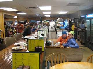
So they took Wis-pee and I to dinner in town. I don't remember being so full, after eating salad and a ton of pizza. They also took us to IGA to resupply, which was wonderful because the store is a mile out of town, and there hasn't been anywhere to get long-term supplies since Lincoln, NH.

While we were shopping, Steve came up and handed us keys: He got us a room at the same hotel they were staying at. It was one of the kindest gestures, the kind that, as Wis-pee said, you hear about happening to other hikers but never to yourself. We couldn't believe our fortune!

It topped a pretty fantastic day on the trail.

I got out of camp at 11 a.m. yesterday at Bemis Mtn. lean-to. What can I say? I slept in, had tea and did some journaling. It was a perfect morning to wake up in the woods.

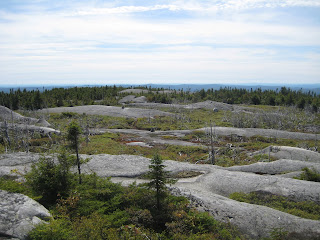
I realized that if I gunned hard for Rangeley, I would have probably the greatest chance I'll get to get back to the kind of hiking I was used to before the Whites make me work for every mile. The terrain was said to be nice and flat.

Along the way I saw a garter snake that wanted to play. It left the trail, then came back towards me, in a nonthreatening way. Katchup and Grommet had seen it, too.


[inquisitive garter snake on the trail, Sept. 2, 2009.]

Photo dump: Hitchin'

I'm trying to take more pictures of the hitchhiking experience. Ever since Vermont, when they started putting trail towns 8 miles out of the way for some reason, hitchhiking has become an increasingly important aspect of hiking the Appalachian Trail.


[Dogs joined me in the back of truck headed out to East B Hill Road, with another hiker in the front seat, Aug. 30]


[Hitching back to South Arm Road from Andover after breakfast, Sept. 1. From left, Billyhoot, Wis-pee, Blacklist and Grommet]

Campfire!

A day after I hiked out of Andover, where I stayed at the Pine Ellis Lodge, I was back in town. It was at noon on Aug. 31 when I hiked down from Moody Mountain to South Arm Road, a country back road, and found Nutmeg and Billyhoot camped out at a stealth site near a big creek and told them I was going to hitch into town for lunch and hitch back out.

Katchup and Grommet joined me and we got a ride from a man and his wife; he moved some flyfishing rods out of his truck bed before we got in. The plan was to get pizzas and beers and bring it all back.

I love it when a Monday goes askew, and suddenly the worst day of the week is totally unfamiliar, in a good way.

We ended up calling David, the manager of the Pine Ellis Lodge, for a shuttle back out because hitching just wasn't happening. In fact I finished my pizza, and a pint of ice cream, on the side of the road at the Andover General Store.


[Andover General Store and diner]

We got back and crossed the stream.


[Grommet and Katchup go into the wild with pizza, Aug. 31, 2009.]

Later on, Wis-pee and Blacklist showed up, and David from Pine Ellis took a break from work to come hang out with us. He busted a couple of jams on his flute and dropped a case of trail magic Budweiser.


[Wis-pee, David, Nutmeg, Billyhoot and Grommet, with the campfire.]

At some point, the idea of breakfast at the diner came up. It turned out that David had an appointment to drop a hiker off at the road at 8 a.m. the next morning. Our luck, he was willing to take us all into town if we showed up.

There was never any doubt about us showing up for breakfast.


[Andover diner, Sept. 1.]

We took over half the counter and the food was delish. I had a bacon cheese omelet with home fries and toast and a sundae for dessert.

PRW news ticker, Thursday, Sept. 3

- I'm in Rangeley, ME, 220 miles from Mount Katahdin. Projected summit date is Sept. 17. It hasn't sunk it yet that I'm in Maine, and that I got here from West Virginia by walking.

- Hikers I've met on my hike are beginning to summit. Pusher, Fly By, Snarl, Apach, Porkchop and Hardcore were the first.

- Mississippi is in Mississippi, uploading sweet photos from the trail.

- Hiking in the Middle East? Know your borders, I guess. Three American hikers have seen their Iraq hike [can some news person do a story about how that came about?] turn into an espionage case in Iran.

Looking back at New Hampshire

My contribution to the AMC [Appalachian Mountain Club]:

- $34
- 3 and 1/2 hrs of work

In return, I got seven nights of shelter and six awesome meals. I was in the White Mountains from Aug. 13, when I climbed over Moosilauke, until Aug. 26, when I crossed NH Rte. 2, the northernmost road leading to Gorham. For the days I hiked in the Whites, my average daily distance was just more than eight miles.

No pain, no Maine

Here's a series of photos from last week that correlates with posts I wrote in Andover.


[Heading towards Full Goose shelter, the second shelter in Maine, in the evening. Aug. 27, 2009]


[The beginning of the Mahoosuc Notch, Aug. 28.]


[Getting into the Mahoosuc Notch takes some dexterity. I had to de-pack twice to squeeze through.]


[Baldpate Mountain on Aug. 28, the day before I climbed it.]

New trail terms

To stealth camp: To camp somewhere not specifically designated for camping, like this.

SoBo/NoBo: Southbounder, northbounder.