Showing posts with label Georgia. Show all posts

Thursday, March 18, 2010

Photo dump, March 15-16

With the change to daylight savings time and more warm, sunny days, I'm getting in more miles and taking more photos.


[Campfire at Blue Mountain shelter, March 15. iTrod, Kate, Emily, Allgood, guy from NC whose name I didn't get, other guy. The shelter stands on a mountain at 3,900 feet elevation; lots of wind. Couple of industrious hikers found a tarp near the privy and shielded half the open face of the shelter with it.]


[Bear bags hanging from bear cables at Blue Mountain shelter. The cables take the trial and error out of hanging your food in the trees at night, which is good.]


[Eastward vista from the summit of Rocky Mountain, elev. 4,017 ft., 52 miles north of Springer, March 16. Nice day!]

Day 113 on the trail: Zero day in Hiawassee

Two nights ago, I camped out in a gorge ringed by a USFS service road, out of the wind and just six miles from Dicks Creek Gap. It was just me and a couple and their dog.

They stayed in their tent while I, after arriving in the evening on the back of a 13.4-mile trek, went about the series of necessary camp tasks that comes with hiking the AT: Get water, hang line for bear bag, change some clothes, set up tent and set up camp stove. Then make dinner, brush teeth, hang bear bag. Next, hang laundry to dry, gather things, make bed. Efficiency grows with repetition.

Most people I have been seeing at camp this past week were staying at the Tray Mountain shelter, six miles south, but I wanted to be close enough to be able catch the morning shuttle into Hiawassee, mainly because my food supply was down to fig newtons and grape jelly, and a pack of Lil' Debbies that Two Dogs [AT '07] handed out as trail magic at Indian Grave Gap [just before Tray Mtn.]

Which is how it should be. If you're doing it right, you're supposed to be out of food whenever you hit your next resupply point.

I set my alarm and started hiking before dawn on Wednesday, jamming on my iPod and rocking my headlamp up Kelly Knob [elev. 4,276 ft.]. New band to check out, if you haven't: Glasvegas, of Glasgow, Scotland.


[View of the rising sun from the AT just past Kelly Knob, northern Georgia, March 17.]

 I got to the road at 9 a.m. At 9:30, Ron Haven, whom Baltimore Jack called the "Donald Trump of the AT" because he owns three hiker-friendly hotels in Franklin, NC and just bought the Hiawassee Inn, pulled up in a yellow short bus to drop off some hikers and pick new ones up. I jumped on board. He's a friendly Southern fellow who makes our lives easier down here.

So now I'm in Hiawassee. I've already resupplied [I bought some dried veggies and a little jar of pimento, so a new lunch wrap recipe is imminent]. Later I'm going to cover my calves and my left heel in muscle cream and relax my legs. Ashley said last night my Achilles problem is a sympathy injury for David Beckham, whose Achilles rupture was heard 'round the world this week.

There's only about eight miles left of Georgia; so far, I've hiked 76.3 miles. That's Week 1 behind me!

Hiawassee:


[Side of a Main St. auto body shop in Hiawassee. Signs of Bible Belt culture abound: No taverns, Christian speech prominently displayed.]

"A footpath for those who seek fellowship with the wilderness"

Sunday, March 14, 2010

Next up on the AT

Christian youth from a Savannah bible college are serving hamburgers for breakfast outside the Walasi-Yi.

The next stretch of trail will take me 30-some miles to Hiawassee. I'm going to go extra slow because my left Achilles is inflamed. Hopefully I'm there on Wednesday.

The cookout last night? Called the Blaze of Glory party unofficially by the staff here, it celebrates the beginning of the thru-hiking season. The food was incredible: Barbecue chicken, venison stew, jumbalaya, red velvet cake, etc. etc.

I was the 202nd thru-hiker to register at Amicalola Falls State Park visitors center. I don't know how the people who start at Springer are counted. But this week will definitely see hundreds of additional hikers start the trail.

Saturday, March 13, 2010

Photo dump


[Me at the start to the Approach Trail, March 10. Josh, Leigh's husband and co-owner/operator of Hiker Hostel in Dahlonega, drove a bunch of us up Springer Mountain in his Suburban, swerving through deep, muddy ruts as we passed by Army Ranger cadets. The Frank B. Merrill training camp is close to, nay, right next to, the trail in Georgia.]


[Section of Georgia trail. One of the rare moments it was safe to get out the camera.]


[Evidence of a controlled burn.]

The first few days...

...have been rainy. Yesterday I counted three unique storms on my way from Gooch Mountain shelter to the Walasi-Yi outdoor center at Neel's Gap.

There was still ice at the top of Blood Mountain. I took a Gatorade break near the Blood Mountain shelter, a frightening stone structure with plastic sheets blowing in the empty windowsills. Sloshing down the two miles of downhill, soaked head to toe, gave me a flashback to when I headed into Rutland last summer. This time my electronics were still intact at the end of the day.

Another memory, from when I was a newbie last summer: Sitting under the Port Clinton pavilion on a June morning, I'm talking about how I need to get a pack cover. It's been raining quite a bit. Half Moon says, "You don't have a pack cover?" giving me a skeptical look. I can appreciate his point of view now.

On my first day, I saw a hiker waiting at the bottom of the 604 steps straight up Amicalola Falls with his 70 pound pack, as though he were waiting for it to sprout legs and hike itself. Further on I passed a big fat man in a big fat pack hiking in flip flops. At the first shelter, where I ate lunch, two guys were in their sleeping bags in the afternoon, and one of them said they'd run out of fuel. He seemed to feel aggrieved that I didn't offer to cook them both dinner; I left them to their misery. Some people are just helpless.

Other people, like a German woman and her 12-year-old son who started with over-heavy packs, have been doing everything right and possess the spirit of self-reliance, but they just have too much stuff. People like them will find help and good advice and come back stronger.

At Neel's Gap the staff is renowned for giving newbie hikers the "shakedown," where they weigh your most likely overweight pack, go through it discarding anything they see as frivolous and set you straight. I got the "You're looking trim already" seal of approval when I walked in the door yesterday, so that's cool.

I'm splitting up a cabin with Cheeks and Mojave Rain, a couple who met on their '07 thru-hike, got married, and are now practicing for their PCT '10 hike. I met them on my first night at Stover Creek shelter.

Last night we had hiker feast in the hostel here at the Walasi-Yi, Mexican cuisine prepared by Baltimore Jack and Miss Janet. Baltimore Jack is something of a trail legend, having completed a ridiculous number of thru-hikes [7? 8?].


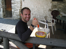
[Miss Janet and Baltimore Jack, March 12. Baltimore Jack is wearing a T-shirt that says "Bill Bryson is a pansy ass." Enormously helpful guy.]

Cheeks scavenged the hiker box and emerged with a gem:


[Cheeks AT '07, PCT '10 with a sweet 1980s-style headlamp, Walasi-Yi.]

And, view from the cabin. It's a good deal. The hostel here is a bit of a dungeon and a lot of hobo-looking people have congregated there.


[View from cabin porch at Neel's Gap, March 13.]

Now I'm going to go read Winton Porter's book before the trails kickoff shindig this evening. There's also a huge cat downstairs and a lot of dogs roaming through the outfitter store that look petable.

Thursday, March 11, 2010

Jellytellarito!

That's the name I came up with for the meal I've had for lunch two days now.  Grape jelly and Nutella in a burrito shell.

It's been a rainy couple of days on the trail.

The picture is of my socks smoking in the Stover Creek shelter, where I slept last night, just two miles north of Springer Mountain.

At approximately 2:47 p. m.  on Wednesday, I hiked past white blaze No.1 of the AT.

Heading for a party - trail maestro and memoirist Winton Porter's birthday - at Neel's Gap tomorrow.

And the trail so far is heaven. Smooth ups and downs and every step on soft earth.

Wednesday, February 24, 2010

Wednesday notes: Heading to the ATC, "A Walk in the Woods" etc.

I'm a member at the Appalachian Trail Conservancy, so I'm off to Harper's Ferry this morning to get the maps for Georgia through southwest Virginia at a discount. I'm also going to ask the assistant on duty what weather I can expect in Georgia.

I've got my Irish drinking songs playlist ready on my iPod - The Pogues, Flogging Molly, The Clancy Brothers, The Young Dubliners and Dropkick Murphys- for March 17. It's something to look forward to. And fyi, Irish/Scottish stuff makes for great music to hike by.

Right now my hiking gear is a messy pile in my bedroom. I've settled on hiking in my old, hopelessly soiled Cap 1 baselayer rather than buy new, because the local outfitter didn't have my size during their huge sale last week. I also dug up a forgotten, barely worn pair of soccer shorts while emptying my dresser which I'll adopt as my primary hiking shorts. As far as other stuff I still need, I got an 18L bear bag, Sea to Summit, with 50ft of nylon cord at Cabela's Monday. All bright orange.

I've also started a lively forum discussion about ranking the extant AT memoirs over at Whiteblaze. Check it out if you're really into reading about the trail and you're exasperated when you browse Barnes and Noble for new stuff and find only the trusty old "A Walk in the Woods."

Which I recently read the first few bits of again. I skipped all the stuff about trail history, geology and the US Forest Service [Bill Bryson hates the USSF] and read just the trail narrative.

Here's a key passage set in Gatlinburg, Tenn. after Bryson and his buddy, Katz, come out of a blizzard in the Smokies:
Katz needed bootlaces, so we went to an outfitter's, and while he was off in the footwear section had an idle shuffle around. Pinned to a wall was a map showing the whole of the Appalachian Trail on its long march through fourteen states, but with the eastern seaboard rotated to give the AT the appearance of having a due north-south orientation, allowing the mapmaker to fit the trail into an orderly rectangle, about six inches wide and four feet high. I looked at it with a polite, almost proprietorial interest - it was the first time since leaving New Hampshire that I considered the trail in its entirety - and then inclined closer, with bigger eyes and slightly parted lips. Of the four feet of trail map before me, reaching approximately from my knees to the top of my head, we had done the bottom two inches.
I went and got Katz...One thing was obvious. We were never going to walk to Maine."
The first time I read that I was like, 'Shit. Really?' and felt deprived of an adventure, since I was reading it with an eye towards hiking WV->ME. Gatlinburg is just about 200 miles into the 2,179-mile hike, mind you. What "A Walk" lacks in that aspect, Bryson more than makes up for it in the breadth of his research and in his laugh-out-loud style.

But it's not the only book on the AT out there. I'll try to post a top five list here once the Whiteblaze discussion wraps up.

Anyway, have a happy Wednesday! Signing off.

Friday, February 19, 2010

Georgia on my mind

...and leaving on a night train to Georgia and all that. It's an inspiring state. For me, however, going to Georgia in 17 days will be my first trip to the Deep South since a week on Edisto Beach, SC in 2005, and my first time going to Georgia that didn't involve driving through or laying over at ATL.

I've got some loose ends to tie up at home and a few last gear essentials to get before packing for the hike. And then it's Week 1 on the trail: One foot in front of the other, just like last June, and getting reoriented.

My first decision as a hiker upon reaching Georgia will be whether to hike or not to hike the Approach Trail.

Nobody I met WV->ME '09 made an urgent case for doing so. It's not like anyone's more impressive for hiking 2,187.9 miles instead of 2,179.1 miles. But I will have the time, since I'm starting fairly early in the season, and I think it'll be good practice for me.

The first white blazes marking the Appalachian Trail appear on Springer Mountain. Like Mt. Katahdin in Maine, the peak lies within a state park with no direct road service to the top. At minimum it's a one-mile hike from a forest road to the peak.

The Approach Trail starts 8.8 miles south of Springer at the visitors center of Amicalola Falls State Park. By the time the trail reaches the peak of Springer [elevation 3,782 feet], it has crossed four roads, passed two shelters and climbed 2,000 feet in elevation.

By contrast, my first day in Maryland took me from 263 feet, over the Potomac River, to a high point of 1,600 feet, over 16 miles of hiking.

Georgia has 176 miles of AT plus the Approach.

The Appalachian Trail in Georgia means 5 things: 1. Chattahoochee, 2. Mountains, 3. Black Bears, 4. Newbies and 5. maybe snow?
  1. Chattahoochee. A 74-year-old national forest in northern Georgia.
  2. Mountains. The trail in the south hits its first 4,000-footer, ominously-named Blood Mountain, 28 miles after Mile 0 and goes on to tap four more 4,000-footers: Blue Mountain, Rocky Mountain, Tray Mountain Kelly Knob. By contrast, my first 4,000-footer on the northern half of the trail was Moosilauke - two months into my hike! The hiking in Georgia is less of a roller coaster than New Hampshire. The lowest the trail gets after Springer is 2,500 feet.
  3. Black Bears. Companion: "With the loss of habitat from development in the mountains, black bears are roaming farther in search of food. To combat this problem, the GATC and the USFS are placing bear cables for hanging food at the shelters most affected." Normal black bear rules apply: Make noise so they hear you coming and get out of the way, no eye contact and back off if you surprise them and stand tall if they charge.
  4. Newbies. Last year the received wisdom that the Recession would send a tumult of hikers onto the trail proved unfounded: It was just like any other year, according to a conversation I had at the ATC in Harper's. That means roughly 1,200 hikers starting the trail in the spring. The peak is March 15 or so. I met hikers in the northern half who started anywhere from March 2 to May. Last June I started hiking and met seasoned hikers who had internalized the thru-hiker culture, etiquette, and ethics. The also-rans had already also-ran and left the trail. This time? Not so. Should be interesting. Stories I heard over the summer lead me to believe so.
  5. maybe Snow? Pictures and stories from the Class of '09 show knee-deep snow in places in the south. A lot of winter camping, sitting around shelters in boggons and bubble coats, with early sunsets and campfires sounds like an acceptable change of pace.
You know what? It seems like the thru-hiking memoirs I've read read at their most vivid in the Georgia chapters ["A Walk in the Woods," "On the Beaten Path"]. I should go back and read those chapters in addition to the  trail journals online.

Guten Freitag!

Friday, February 12, 2010

Countdown: 26 days to GA->WV '10

I've already booked a bunk for the first hostel on the NoBo AT: Hiker Hostel, near Dahlonega, Georgia.

For $70 you get the thru-hiker special: Shuttle from the airport/train or bus station in Atlanta, stay overnight, breakfast and a shuttle to the beginning of the AT.

Look soon for a "What's ahead in Georgia"-type post.